|
In
order to locate and record sites in the landscape, archaeologists
rely on survey or reconnaissance methods. These may be conveniently
divided into three categories: aerial surveys, surface surveys,
and subsurface testing. All share certain basic parameters. First,
the region to be surveyed needs to be defined. Second, the archaeologist
needs to become familiar with the natural and human-altered characteristics
of the area. This step is important in order to develop a feeling
for the features of local archaeological sites and to determine
the most appropriate survey methods. For example, it would be a
waste of time to look for prehistoric material in soil that has
been newly deposited by alluvial (riverine) or volcanic action.
Third, the archaeologist must determine how the information found
by the survey will be used and recorded. Depending on the requirements
of the project and the funding available, archaeologists will use
a combination of the three survey methods to try to find the most
pertinent archaeological information in the most effective way.
Aerial
survey, or aerial reconnaissance, involves the use of various types
of aircraft or satellite to create images of the land which are
then More
can be revealed by aerial photography than might be expected. Shadow
sites are low walls or earthworks that might not be noticeable at
ground level but can cast long shadows that are visible from above
are visible during the low light of early morning or late afternoon.
Soilmarks occur when differences in soil moisture or texture reveal
buried Other forms of aerial imagery are also useful to archaeologists, though they tend to be much more expensive. Thermography uses thermal or heat sensors mounted on an aircraft to record variations in temperature of the land below. Sideways-looking airborne radar (SLAR) uses pulses of electromagnetic radiation sent from a high-flying aircraft to record the features of the land below. Unlike conventional photography, clouds do not interfere with SLAR images. The LANDSAT satellite records the intensity of reflected light and infrared radiation from the earth's surface and converts it to photographic images that can be useful in large scale surveys. As various new forms of imaging technology appear, archaeologists will undoubtedly add them to their repertoire of survey methods. Surface surveys, or ground reconnaissance, are the most common form of archaeological survey, primarily because no special or expensive equipment is generally necessary. When doing a surface survey, archaeologists walk across the survey area, looking for artifacts and surface features. These are then either collected or recorded and then analyzed for site location and type. A
surface survey can be done in either an unsystematic or systematic
manner. In an unsystematic survey, an archaeologist wanders This
potential bias is moderated in a systematic survey where the archaeologist
follows a sampling strategy designed to result in a representative
archaeological data. In the United States, this is generally done
by dividing the survey area into long transects (lines that cut
across the landscape) five to 20 meters apart which are then walked
by archaeologists. Alternately, if a more exact sample is required,
different sampling strategies are used. The region is divided
into units and data is gathered from representative units (see
the Sampling Strategies
Lab for more detail). Subsurface testing methods are generally used alongside surface surveys to locate subsurface features. The simplest of these methods involve physically digging holes, bringing dirt to the surface, and inspecting it for artifacts. This can be done with a variety of tools, including soil corers, hand and power augurs, posthole diggers, shovels, and trenching machines such as backhoes. In the United States, digging test pits with a shovel, also known as shovel testing, is the most popular of these physical methods. Shovel test pits tend to be between 25 to 100 cm in diameter (if round) or per side (if square) and generally about a meter deep (much deeper and the diameter of the pit becomes too small to for effective digging). The pits are dug in levels like a site. Artifacts from each level are recorded and, as with other survey methods, the information is analyzed for site location and type. There
are also a number of different types of remote sensing techniques
that allow subsurface testing without physical disturbance. Ideally,
these allow the archaeologist to look into the ground and see
features lying beneath the surface. For example, magnetic surveying
uses a device called a Proton Magnetometer to measure the strength
of the earth's magnetic field at the surface. When scanning undisturbed
homogenous dirt, the magnetometer registers a smooth plane. Any
disturbance to the homogeneity of the dirt alters the magnetic
reading detected by the magnetometer. Archaeological features
that a proton magnetometer can detect include middens, ditches,
building walls and Unfortunately, because none of these techniques can detect detailed, small-scale features, archaeologists relying on subsurface remote sensing alone would miss many archaeological features. However, these techniques are extremely valuable because they neither disturb nor destroy the archaeological record. Today the technology is bulky, expensive, and limited to ideal conditions; but perhaps someday archaeologists will be able to analyze sites without ever picking up a shovel, instead relying solely on subsurface remote sensing images.
|
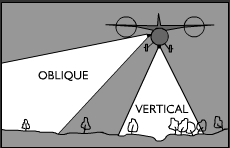 interpreted for archaeological information. Conventional low-altitude
aerial photography is still the most common method of aerial survey.
Pictures can be taken either straight down or at an oblique (or
low) angle. Vertical photographs provide a plan (or bird's-eye)
view of the site and are generally used for mapping in known sites.
Oblique photographs reveal contours and provide perspective and
so are frequently used for site discovery.
interpreted for archaeological information. Conventional low-altitude
aerial photography is still the most common method of aerial survey.
Pictures can be taken either straight down or at an oblique (or
low) angle. Vertical photographs provide a plan (or bird's-eye)
view of the site and are generally used for mapping in known sites.
Oblique photographs reveal contours and provide perspective and
so are frequently used for site discovery. 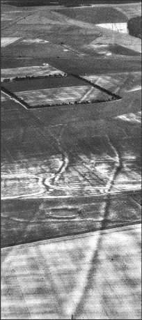 sites. For example, a newly plowed field may exhibit differences
in soil color between a flattened burial mound and the surrounding
area. Cropmarks occur when variation in the height, health, or type
of vegetation growing on the land reveals buried features that affect
plant growth above them. Where the soil is rich with moisture and
phosphates, as over a buried ditch where the earth has been disturbed
in the past, plants tend to be taller, lusher, and more dense than
the surrounding areas. Conversely, over a buried wall or stone feature,
soil will be thinner, drier, and poorer, resulting in plants that
are sparser, stunted, or otherwise different from the surrounding
areas. The photo to the right is a picture of Neolithic structures
in southern England revealed by cropmarks.
sites. For example, a newly plowed field may exhibit differences
in soil color between a flattened burial mound and the surrounding
area. Cropmarks occur when variation in the height, health, or type
of vegetation growing on the land reveals buried features that affect
plant growth above them. Where the soil is rich with moisture and
phosphates, as over a buried ditch where the earth has been disturbed
in the past, plants tend to be taller, lusher, and more dense than
the surrounding areas. Conversely, over a buried wall or stone feature,
soil will be thinner, drier, and poorer, resulting in plants that
are sparser, stunted, or otherwise different from the surrounding
areas. The photo to the right is a picture of Neolithic structures
in southern England revealed by cropmarks. 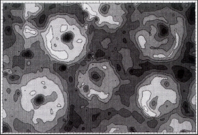 foundations,
hearths, burned structures, and bricks. For example, the photo
to the right is a proton magnetometer map of part of the Big Hidatsa
Village site in North Dakota. Magnetic anomalies created by buried
remains of earth lodges are represented by the large, light circular
features and the fire hearths inside are represented by the smaller,
dark features. The same type of features can be found with Electrical
Resistivity techniques in which a current is passed through the
ground and then measured. Because variations in soil type, water
content , and ion content will affect the subsurface resistance
experienced by the current, archaeological features and other
anomalies can be detected. Ground Penetrating Radar is a similar
technique, but instead of an electrical current fed into the ground,
an electromagnetic pulse is used. If the pulse encounters an interface
between two different materials with different electrical properties,
a portion of the electromagnetic energy is reflected back to a
receiver.
foundations,
hearths, burned structures, and bricks. For example, the photo
to the right is a proton magnetometer map of part of the Big Hidatsa
Village site in North Dakota. Magnetic anomalies created by buried
remains of earth lodges are represented by the large, light circular
features and the fire hearths inside are represented by the smaller,
dark features. The same type of features can be found with Electrical
Resistivity techniques in which a current is passed through the
ground and then measured. Because variations in soil type, water
content , and ion content will affect the subsurface resistance
experienced by the current, archaeological features and other
anomalies can be detected. Ground Penetrating Radar is a similar
technique, but instead of an electrical current fed into the ground,
an electromagnetic pulse is used. If the pulse encounters an interface
between two different materials with different electrical properties,
a portion of the electromagnetic energy is reflected back to a
receiver. |
Questions The following are examples of hypothetical regions that need to be surveyed. Using the descriptions of the projects and aerial photos of the landscapes, decide which survey techniques you would use and why. Answers should be in short essay form and must be typed. |
|
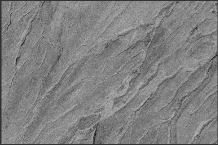
1.
Region A is situated in a Caribbean landscape that has been covered
by a relatively uniform 145 cm (appx 58in) ash flow from a nearby
volcano. This has resulted in a flat ground-surface with no visible
underlying features. There is no significant vegetation growth in
this area that might affect your survey. You are interested in locating
the stone foundation of a Colonial plantation house that is known
from historical documentation to lie within the survey region.
|
|
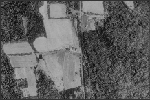
2.
Historical documentation indicates that a huge battle was fought
between Celts and Roman soldiers somewhere within Region B in southcentral
England ca. 50 BC. You are interested in finding the extent of the
battle and determining how it progressed. No earthworks or other
physical defenses were used, so you will have to rely upon artifacts
from the soldiers themselves. The area is currently covered by woods
and small fields.
|
|
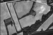
3.
Region C is an area in rural South Carolina that is to be made into
a retirement community. It is currently mostly farmland crossed
by small belts of trees. You have been able to find no pertinent
historical information about this particular piece of land, but
you know that the region has been inhabited for thousands of years
by Native Americans and for hundreds by European and African immigrants.
|
|
|
|
|
| Illustrations modified from Archaeology: Theories, Methods, and Practice, Renfrew and Bahn. Thames and Hudson Ltd., 1991 and from Field Methods in Archaeology: Seventh Edition, Hester et al. Mayfield Publishing Co., 1997. |